Hello, Welcome to the latest edition of Branches, ATREE's quarterly newsletter. We are excited to share the latest updates and insights from our diverse range of projects. Explore with us as we highlight the innovative methodologies and impactful findings that define our ongoing research efforts. Join us on this journey through the branches of knowledge as we strive to make a meaningful difference in our environment and society. |
|
|
|---|
|
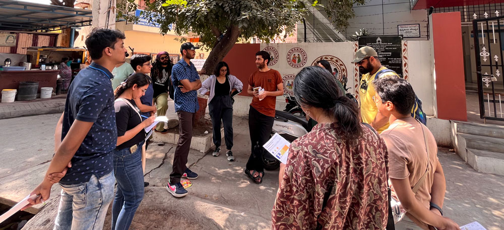
PROJECT Built Environment and Hyper-local Climate Action: Understanding Heat Stress in Marappanapalya Ward, Bengaluru by Dr Manan Bhan and Ujjvala Krishna |
|
|---|
|
| | | | | |  | | | | | | | | | |
| BACKGROUND
Heatwaves have emerged as one of the major extreme weather events around the globe. Indian cities sit squarely in the middle of the unfolding climate crisis – heat stress is likely to increase as extreme heat events continue to worsen. Such heat-stress leads to negative impacts – on each individual, community and system, leading to health and productivity losses, infrastructural damage and economic losses. Bengaluru, once known to have an agreeable climate throughout the year, is expected to face immense heat-stress over the next few years due to climate change, exacerbated by the alarming rate of disappearance of green spaces.
PROBLEM
Urban heat, resulting from the absorption and re-emission of solar heat by buildings, roads and paved surfaces, gives rise to localised hotspots known as Urban Heat Islands (UHIs). Climate change is amplifying the development of UHIs and the occurrence of extreme heat events, carrying significant consequences for public health, the environment, economy and infrastructure. Response to heat-stress in urban India is dominated by top-down actions. There is a lack of systems-level and decentralised understanding of impacts and potential responses that can be evolved to tackle heat-stress at the local level.
We centre our efforts in Bengaluru at the ward level. At this level, the interactions of heat-stress with local systems like health, water, economy, energy and the built environment can be better visualised and understood. We are guided by two learning questions: What are the pathways through which heat interacts with different elements in the ward? How can we bring different types of information together (demographic, biophysical, built environment) to respond to the emerging risks of heat-stress?
OUTCOMES
Our approach combines three aspects of understanding this impending challenge: a systems-level framework of heat-stress and its impacts at the ward level; technical approaches to identify areas of maximum exposure within the ward; and sensory experiences for citizens to better understand local contexts from the perspective of heat-stress. One output is a Climate Vulnerability Walk, where participants walk through the ward to better understand the risks from heat-stress – for instance, who are the stakeholders most vulnerable and what are the potential solutions to adapt at a systemic level? The walk as a medium of interaction helps communicate complex biophysical, demographic and socio-ecological information in a manner that is participative, helping bridge the gap between a top-down understanding of climate action and the lived reality of adapting to climate change. | | |
|
|
|
|---|
|
|
PROJECT Securing individual forest rights for the forest villages of Madhya Pradesh using geospatial technology and grassroots capacity building by Mohit Mahajan, Venkat Ramanujam and Sharachchandra Lele | | | | | | | 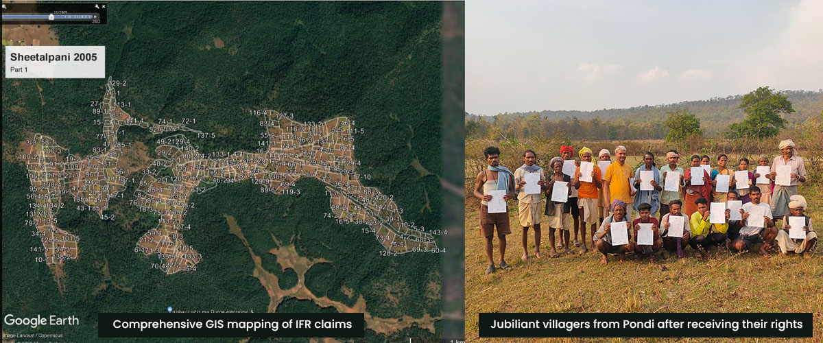 | | | | | | | | | |
| BACKGROUND Forest Villages (FVs) are villages created by the colonial forest departments by settling Adivasis within specific patches of Reserve Forests to ensure a permanent supply of labour for forestry operations, mainly timber felling. This extreme form of historical injustice, where they paid for temporary cultivation permits through compulsory forest labour and lived permanently under the control of the forest department, continued after Independence in most central Indian states. Dindori district has 86 such FVs. The Forest Rights Act of 2006 provides for the conversion of forest villages into revenue villages, but such conversion must be preceded by complete recognition of all cultivation plots and habitations within the village boundary as Individual Forest Rights (IFRs). PROBLEM Even 18 years after the enactment of the FRA, recognition of IFRs in FVs is very low, ranging between 20 and 50% of the actual cultivated/inhabited land in our sample from the 86 FVs in Dindori district, Madhya Pradesh. This is because the process of claim-making here is largely controlled by the forest department, and the rest of the bureaucracy and the political system are simply unaware of the special history of FVs that cries out for 100% IFR recognition. Furthermore, the IFRs that have been recognised are riddled with problems: poor or non-existent plot maps, wrong areas or wrong locations. SOLUTIONS We adopted a three-pronged approach in the FV-dominated Baiga Chak region of Dindori district: explaining the special history of FVs to the administration and the incongruities in the IFR recognition, building capacities of the Forest Rights Committees (FRCs) in the FVs, and ensuring accuracy in the claim-making process using geospatial technology. We piloted the process in two villages – Pondi and Sheetalpani – and trained FRC members and volunteers to carry out mapping. Aamcho-CFR, a handy mobile-based app developed by ATREE, was used along with other apps as backups. Wall-to-wall mapping of the cultivation and homestead plots within the boundaries of FVs was completed, with ownership and IFR recognition status. The results, which showed a random subset of plots getting recognition in a contiguous cultivated landscape, convinced the District Collector of Dindori of the problem, and ATREE was invited to facilitate comprehensive claim-making in these two pilot villages. Claim-making camps were organised by the FRCs. The entire village scrutinized all maps, suggested corrections, resolved conflicts and approved the claims. Each claim contains GIS maps of each plot of land.
OUTPUT The District Level Committee (DLC) of Dindori has recognised that all maps and claims are correct. IFR titles have been issued in the first round for about 70 % of claims, while they await some clarifications. The Collector has sought exemption from the state-mandated excessively digital process that does not work in these remote and low-literacy villages while asking us to help them scale up the process to the remaining 84 FVs in Dindori. The use of a historically informed and people-centric process, supported by easy-to-use and transparent geospatial technology, has boosted the confidence of the community. People from other villages of Baiga Chak and elected representatives have visited Pondi and Sheetalpani and are participating in our training programmes. As awareness increases, these gram sabhas are passing resolutions for re-initiating the IFR process. We dedicate this article to Sunaram Nawasiya, our colleague, friend and senior Baiga Adivasi leader from Baiga Chak, who passed away on 17 February 2024. | | |
|
|
|
|---|
|
|
PROJECT Transforming lives through efficient energy technologies and the restoration of degraded lands in the tea landscape of Darjeeling, India by Sanjeeb Pradhan, Tenzing Sherpa, Passang Nima Sherpa, Mingma Tamang, Nirmala Pradhan and Nima Tamang | | | | | | | 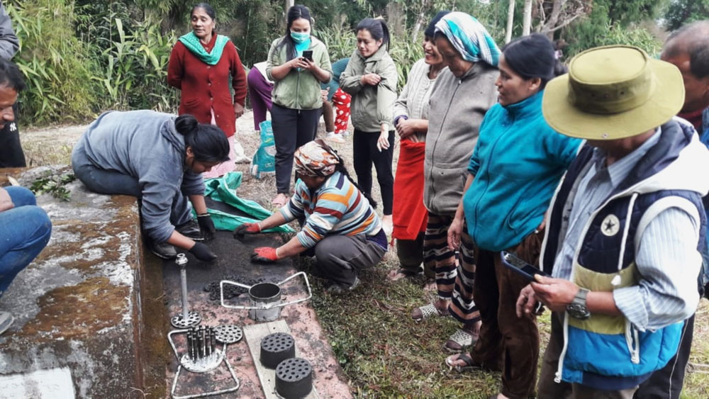 | | | | | | | | | |
| BACKGROUND Darjeeling district consists of Tea Gardens (TGs) established in the middle of the 19th century to enhance revenue generation. The district also comprises vast agricultural landscapes where farming is done for subsistence as well as commercial purposes. The land ownership in the areas of the district located in the hills is mostly small and marginal. For a district where most of the population is rural, the lives and livelihoods are deeply intertwined with biodiversity and ecosystem services. However, with local impacts of global climate change involving uncertain weather (precipitation) patterns (rainfall, hail, frost), the Darjeeling areas face impacts on agriculture, disasters, water security and diseases, to name a few. Additionally, this also impacts local biodiversity and ecosystem services. PROBLEM Most households in the Tea Garden depend on fuelwood for their cooking and space heating needs. Fuelwood is mainly from the surrounding forests and their agroforestry plots. Liquefied Petroleum Gas use has its challenges in the form of intermittent supply from legal agents, extra payment from other sources and transportation costs over remote and difficult terrain, thus limiting its use for special or emergency occasions. The biomass harvest for energy is known to be linked with forest degradation and carbon emission, both detrimental to biodiversity and ecosystems.
SOLUTIONS Given this dependence on forests for energy use, energy-efficient technology has the potential to reduce the amount of fuelwood consumed, thus reducing carbon emissions. This will also reduce the threat of forest degradation through reduced collection of fuelwoods from the forests. Additionally, it has the potential to improve indoor air quality, thus reducing respiratory health hazards, especially for women and children. Furthermore, it reduces the drudgery women, mostly involved in fuelwood collection, face. Since 2022, we have been implementing the project funded by Norton LifeLock through its CSR initiatives in 11 tea gardens of Rangbang Valley, Darjeeling, aiming to promote efficient energy technology training, demonstration and installation. Furthermore, the project aimed to create a pool of master trainers and thereby provide them an opportunity to scale up these energy-efficient units beyond the project landscape. The project also helped in initiating degraded land in Tea Gardens in coordination with the tea management and communities.
OUTCOMES Members of 1162 households benefited from ICS installation through improved health pertaining to respiratory diseases by reducing indoor air pollution, thus helping to meet the progress towards attaining the Sustainable Development Goal on Health (SDG 3).
A pool of 149 master trainers trained on ICS installation, of which 86 were women.
Reduction in fuelwood consumption by 25–30% and an increase in efficiency by 25% through adoption of Improved Cook Stoves, thus indirectly preventing forest degradation.
107 women of 23 SHG groups, trained as master trainers in manufacturing bio-briquettes from tea garden waste and other biomass, could sell 1800 pieces at 30 rupees per piece, especially for use as space heating during winter.
The degraded tea garden land of 6.83 hectares was restored by planting 9181 saplings of 18 indigenous multipurpose tree species.
| | |
|
|
|
|---|
|
|
PROJECT
Conservation of threatened forest and biodiversity of Siang Valley, Eastern Himalayas by Rajkamal Goswami and Monsoon J Gogoi |
|
|---|
|
| | | | | |  | | | | | | | | | |
| BACKGROUND
In the Eastern Himalayas of Arunachal Pradesh, India, lies the Siang Valley, a region that is as breathtaking as it is vital to both the local and wider ecosystem. Spanning 18,518 square kilometres – larger than Fiji – this area, named after the Siang River (also known as Yarlung Tsang Po upstream and Brahmaputra downstream), is home to 0.22 million people, most of whom belong to the indigenous Adi, Galo, Tangin, Memba and Khemba communities. Despite official statistics showing 84.4% forest cover, Siang Valley faces significant conservation challenges that threaten its incredible and largely unexplored biodiversity, with about 80% of the forests lying beyond the Protected Areas (PAs) network. PROBLEM
Between 1986 and 2021, Siang Valley witnessed the disappearance of around 100,000 hectares of dense forest, indicating a disturbing trend towards forest degradation. Large dam projects, rampant illegal timber logging, illegal hunting and the demand for cash crops remain critical threats to the valley's forests and biodiversity. These threats not only endanger the habitat of countless species but also undermine the culture and livelihoods of the local communities. OUTPUT
Our conservation strategy in Siang Valley hinges on three critical pillars:
Empowering the local communities to identify key sites and co-create conservation strategies. This community-led approach aims to protect and sustain the bulk of the biodiversity that lies outside the PAs. Strengthening forest management within the PAs by enhancing the capabilities of the forest department to ensure these forests remain the strongholds of extant biodiversity. Mainstreaming the idea of biodiversity conservation in Siang Valley.
OUTCOMES
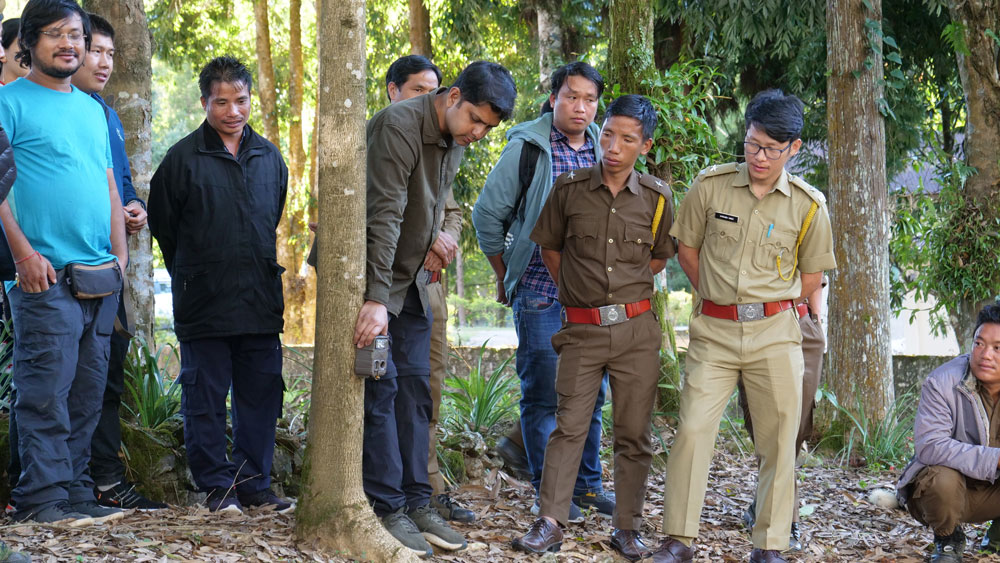
In partnership with the local communities, we have identified about 10000 ha of intact forests based on a prioritisation model we co-designed and co-implemented with the local communities. Engagement with the forest department has resulted in the first-ever camera trapping exercises inside Mouling National Park, from whose boundaries the nearest motorable road lies about 12 km away. Within the broader effort to integrate biodiversity conservation into the mainstream fabric of the local communities, our public bird-walk events engaging young people with the beautiful and inspiring aspects of biodiversity have gained considerable popularity. | | |
|
|
|
|---|
|
|
PROJECT The restoration of biodiversity and ecosystem services of Venkateshpura Lake, Bengaluru by Soubadra Devy, Priyanka Jamwal, Vardhini Suresh, Chethana Casiker, Pavan Naik, Sunil G. M. and Jagadisha Kumara B. | | | | | | | 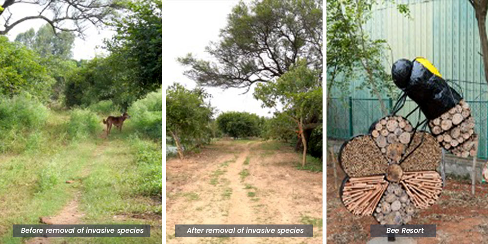 | | | | | | | | | |
| BACKGROUND Venkateshpura Lake is a small neighbourhood lake in north Bengaluru. While large heritage lakes often garner attention and resources, small neighbourhood lakes, which also provide multiple ecosystem services, are often ignored. While the focus of restoration efforts is mostly on the lake’s water quality, the shores of the lake usually get paved for running tracks and the greenery that is created is bereft of biodiversity. Paving also makes it impervious to water and leads to run-off during rains.
The spaces around Venkateshpura Lake were reimagined to support biodiversity without compromising the aesthetics of the lake. While the plan is to make it a refugia for multiple taxa, our current efforts focus on enabling support for bees.
PROBLEM Venkateshpura Lake’s water quality has deteriorated over time due to the inflow of sewage, causing the growth of invasive plants such as Pistia stratiotes. The lake shore was filled with invasive species such as Lantana camara and Parthenium hysterophorus.
Biodiversity surveys indicated low diversity and an abundance of solitary bees in and around the lake. Solitary bees play an important role in pollination but do not receive the attention that honeybees do. Due to urbanisation and the ongoing expansion of the concrete jungle, they are losing their natural habitats, particularly nesting habitats.
OUTPUT We have removed Lantana camara from the shore of the lake and continue to manage Parthenium hysterophorus. We have replaced invasive species of plants with native species that support the local biodiversity.
We see potential for the lakeshore to provide nesting sites and foraging grounds for a variety of bee species. A set of plants that attract different species of bees has been planted along the trail.
We have set up a large ‘bee resort’ to provide nesting space for solitary bees. Wooden logs pitted in varying sizes to attract multiple species of cavity-nesting bees have been placed inside the bee installation. The installation, resembling a large carpenter bee landing on a flower, is so designed to draw the attention of people, especially trail users, to solitary bees. Bee-friendly plants around the installation provide forage and supporting material.
We are thrilled that the solitary bees have started colonising the ‘bee resort’. Alongside efforts are also underway to improve lake water quality using a suite of nature-based solutions which include floating islands and constructed wetlands which will remove the pollutants in the water. | | |
|
|
|
|---|
|
|
PROJECT Evidence-based legislation, strong institutions and consensus needed to mitigate the negative impacts of free-ranging dogs by Sergio A. Lambertucci, Lucía B. Zamora-Nasca, Asmita Sengupta, Marina de la Reta and Pablo I. Plaza | | | | | | | 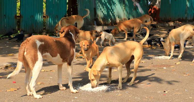 | | | | | | | | | |
| BACKGROUND Dogs have coexisted with humans for over 30,000 years benefiting us in a multitude of ways. While having dogs as pets is a common practice across the globe, dogs without responsible ownership and that move freely (free-ranging dogs henceforth) account for ~75% of the canine population worldwide. Across many countries, especially in the Global South, humans and free-ranging dogs share spaces and their relationships can vary greatly from being affiliative to indifferent to agonistic, making the human–dog interface a complex socio-ecological system. Free-ranging dogs can detrimentally affect human health, livelihoods and wildlife and these problems are becoming increasingly frequent globally. The active management of this socio-ecological system is an immediate requisite for reducing and/or eradicating these negative impacts. We aimed to identify the challenges for managing the human-dog interface and propose pathways for overcoming them by examining the issue in India and South America – two regions characterised by large dog populations and where negative human-dog interactions are increasingly being reported both in the scientific literature and popular media. PROBLEM
While the negative impacts of free-ranging dogs on wildlife, human health and livelihoods are well-documented, current actions to mitigate them in both the regions appear to be insufficient. There are diverse challenges that need to be addressed in this regard such as irresponsible dog ownership, unregulated provisioning of free-ranging dogs, limitations and faulty functioning of animal shelters, power asymmetries among relevant stakeholders and uncontrolled dog populations. An overarching obstacle that underlies all the challenges is the lack of or inadequate legislation concerning the management of dogs in public spaces. For example, in Argentina and India, euthanasia of dogs is illegal although rabies-infected dogs can have serious public health implications such as pathogen transmission and physical attacks on people. Moreover, the Animal Birth Control Rules in India encourage people to provision dogs, thereby ignoring scientific evidence that shows such food subsidies can induce hyper-aggressive behaviour towards people even among sterilized dogs. Although the Prevention of Cruelty to Animals Act 1960 considers abandoning animals a punishable offence, the lack of pan-country laws governing pet registration and licensing in India further promote irresponsible dog ownership. SOLUTIONS We suggest strengthening six key points based on the challenges that we identified: (a) devising and implementing appropriate legislation, (b) improving outreach programmes to enhance responsible ownership, (c) expanding free spay-neuter programmes, (d) increasing the capacity and geographical coverage of animal shelters, (e) legislating, prohibiting and controlling intentional and unintentional feeding of dogs and (f) using a combination of non-lethal and lethal techniques for controlling dog populations, as per requirement. For these steps to be effective, it is essential to strengthen relevant institutions and (re)formulate policies based on scientific evidence. CONCLUDING REMARKS It is important to understand that there is no singular template for mitigating the negative impacts of free-ranging dogs. India and South American countries might be dealing with similar issues with regard to free-ranging dogs, but they have vastly different populations and cultures. Thus, while the six-step framework that has been proposed can be adopted globally, each region should use a combination of methods to manage the human–dog interface that cater best to their situations in terms of requirements, capacities and values. While humans and several wildlife species are deleteriously impacted by free-ranging dogs, the dogs themselves are malnourished, afflicted by severe infections and face human harassment. Evidence-based policies leading to properly implemented and monitored actions alongside well-developed outreach programmes can benefit humans and dogs alike. | | |
|
|
|
|---|
|
|
PROJECT Changing roles of nandavanam in the Anthropocene: Opportunities for wilding by M. Mathivanan, A. Thanigaivel, A. Saravanan, S. Thalavaipandi, S. Thamizhazhagan and P. Maria Antony | | | | | | | 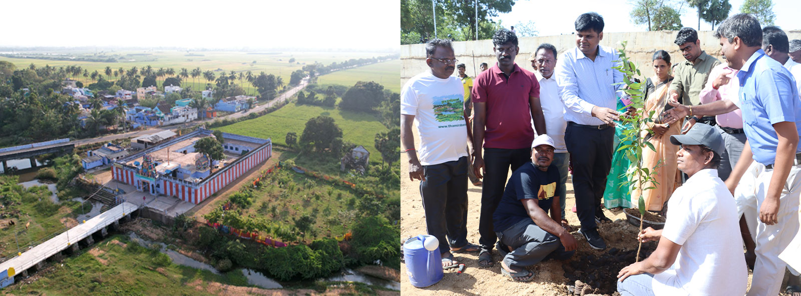 | | | | | | | | | |
| BACKGROUND Temple nandavanam (sacred garden) is an age-old practice of conserving native trees and associated biodiversity in the temple backyard, which acts as green fencing and holds native traditional trees and shrubs. The plants are beneficial to the temple as well as the community residing in its vicinity. Nandavanams host unique assemblages of biodiversity and act as a gene bank of traditional plant species. Today they are the last remaining green spaces in the human-dominated landscape in many regions and play a vital role in human mental health and peace. Conserving nandavanams has the potential to ensure human well-being and support wildlife if restored. PROBLEM Many nandavanams suffer from inadequate maintenance, leading to various issues. One common problem is the introduction of commercial and exotic plant species, which can disrupt the ecosystem balance. Additionally, land encroachment poses a significant threat to the integrity of these sacred gardens. Paved pathways, while intended for convenience, can further degrade the natural environment and hinder the growth of native plants. Compounding these challenges is the absence of dedicated gardeners to oversee the proper care and upkeep of these green spaces. Addressing these issues is crucial to ensuring the preservation and vitality of nandavanams for future generations.
APPROACHES The project Namma Ooru Nandavanam was designed as a multifaceted initiative to enhance green spaces within a human-dominated landscape. This project highlights the significance of native trees and Sthalavriksham (tree species dedicated to the temple), integrating stakeholders' preferences in the selection process. Through an holistic approach a list of heritage Hindu temples were compiled from the Hindu Religious & Charitable Endowment Board. To streamline the data collection process, an Open data kit (ODK) form was developed, employing a citizen science approach. Volunteers underwent training to effectively contribute to the project. Data collection encompasses various aspects such as temple tree species, girth at breast height, height measurements, biodiversity observations, identified uses, potential threats, geographical coordinates and photographic documentation. Following data collection, a rigorous validation process was implemented to ensure accuracy and reliability.
OUTCOMES The survey was conducted in 131 temples in Tirunelveli district, Tamil Nadu. Over 3664 trees belonging to 97 species were recorded; Neem trees (841)were recorded in maximum, followed by Coconut (512), Bael (307), Teak (196), Mango (120), Peepal (102), Arjuna (102). More than 50 individuals of each tree species of Mahua, Indian beech, Amla, Tamarind, Banyan and Jamun were recorded. Of the 131 temples, 7 did not have any trees and around 50 had less than 10 trees. Around 96 temples had less than 10 species of trees. Six Namma Ooru Nandavanams establishmented, the project introduced over 600 plants representing more than 100 species, enriching the local environment and promoting biodiversity conservation. These nandavanams feature diverse components, including flower gardens, herbal gardens and areas dedicated to butterfly host and nectar plants Additionally, native xerophytes were planted in zones were soil conditions were poor an was not suitable to support other vegetation. Over 10 acres of land have been converted into functional nandavanams with the support of the Tirunelveli district administration, Hindu Religious and Charitable Endowment Board, local NGOs, volunteers and government line departments. This is a part of the ongoing effort to restore multiple ecosystems in the Agasthyamalai landscape. We hope to bring in another restoration story in the following issue. | | |
|
|
|
|---|
|
You could create a huge impact, we look forward to your contribution |
|
|---|
|
ATREE, Royal Enclave, Sriramapura, Jakkur Post, Bangalore 560 064
Phone: +91-80-23635555 | www.atree.org | info@atree.org |
|
|
|
|---|
|
|
|